Jambusar Fm
Type Locality and Naming
SUBSURFACE: Well Jambusar-1 (depth interval 100-408 m), It is of 308 m thickness. [Original Publication: Chandra, P.K. and Chowdhary, L.R. (1969) Stratigraphy of the Cambay Basin, ONGC Bull., vol. 6 (2), pp. 37-50.]. Reference well: i) Broach-6 (depth interval 184 – 800 m); ii) Cambay-40 (depth interval 285 – 487 m); iii) Nawagam-22 (depth interval 137 – 255 m). In Broach-6, the thickness is 616 m while in Cambay-40 and Nawagam-22 the thickness is 190 m and 118 m, respectively. (after Pandey and Dave, 1998)
Lithology and Thickness
Sandy clay. In holostratotype, it consists of yellow and grey clays, coarse sand and kankar. In Broach-6 it is composed mainly of coarse sands, kankar and clay. In Cambay-40, it is composed of grey to dark grey claystone, coarse-grained sandstone, gravelly sands with minor shale. In Nawagam-22, the dominant lithology is yellow and grey clays, coarse sand, gravels and kankars.
NOTE: " Kankar or kunkur is a sedimentological term derived from Hindi, occasionally applied to detrital or residual rolled, often nodular calcium carbonate formed in soils of semi-arid regions. It forms sheets across alluvial plains and can occur as discontinuous lines of nodular kankar or as indurated layers in stratigraphic profiles more commonly referred to as calcrete, hardpan or duricrust." (from Wikipedia)
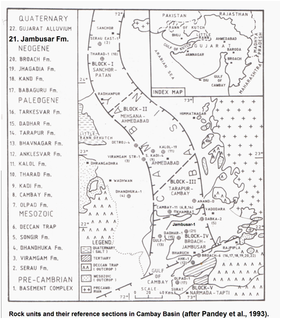
[Figure 1: Rock units and their reference sections in Cambay Basin (after Pandey et al., 1993)]
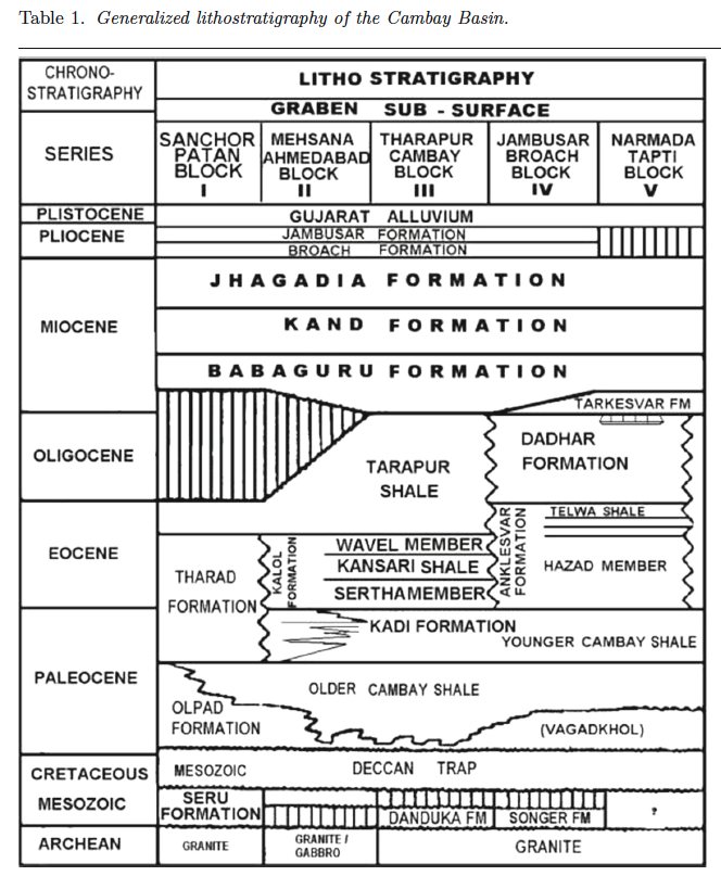
[Figure 2: Generalized stratigraphy of the Cambay Basin. (from Jaiswal and Bhattacharya, 2018, J.EarthSyst.Sci., 127:65)]
Relationships and Distribution
Lower contact
It is conformably underlain by the Broach Fm.
Upper contact
It has a gradational contact with the overlying GujaratAlluvium Fm. The upper boundary of the formation is not well defined.
Regional extent
In the north, the formation extends up to Kalol field and in the south it extends up to Narmada river. To the north of Kalol up to Sanchor, the formation emerges in Gujarat Alluvium and the formation is indistinct. The formation is represented by agate conglomerates which are outcropping in coastal areas south of Gogha.
GeoJSON
Fossils
The formation contains species of Sphaeroidinella, Cibicides, Elphidium, Globigerina, Nodosaria, Nonion, Spiroloculina, Toralia, Eponides, Quinqueloculina etc.
Age
Depositional setting
Additional Information

